Showing posts with label north. Show all posts

2009-06-02

Keelung to Taipei in 01:03 (騎省道台五線輕鬆地打通基隆及台北的界線)


I’ve long taken to cycling around Keelung as a primary - rather than alternative - mode of transportation. With the exception of winters, which do get unpleasantly damp and dreary, the city and its immediate periphery are not just cyclable, but compact and ‘visually interesting’ - prompting feelings that many more people, with two good legs and an agenda not callling for heavy shopping, should leave their car or scooter in the garage and venture out on bicycles.

Apart from exercise and convenience, cycling allows ‘ponder time’ – time to think about this and that, including ways of making the immediate neighborhood, Taiwan and the world greener and more sustainable.

I’ve been cautioned by numerous friends and strangers of the dangers of Taiwan roadways - plagued as they are by fast drivers more concerned with getting to point B than with the occasional cyclist (or pedestrian) in the way. To this, I might add precariously double-parked vehicles, road debris, potholes, steep curbs and (particularly when caught at a stoplight behind a row of motorcycles) bad air. Most roads here simply are not ‘cyclable’ in the ideal sense of the word. Many a conversation has simply ended on that note. It would be wonderful if - by some adroit stroke of policy or, perhaps, by gasoline prices inching their way beyond the reach of casual motorists … or by more people simply electing to bike - more drivers began commuting hither and thither on bicycles.


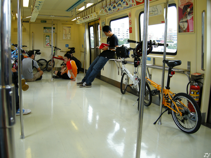
As seen to some degree already in neighboring Taipei City, the simple act of installing recreational cycling trails around the urban periphery has spawned an entire new generation of cyclists happy to don quirky Styrofoam helmets and lug odd-looking 'collapsibles' onto the MRT. As more people propel themselves with pedal power, we naturally grow more aware of the potential and the need to make urban environments more ‘user friendly’. Pressures for real commuter bike trails, safer roads, better air quality, better regulations, better urban planning … all come gradually into play and help foster (hopefully) a better environment across the board. Keelung City, still visibly deficient in both imagination and self-confidence, remains, physically and spiritually, so far removed from any of this … but one must first dream.


Sign warns of malevolent local auto with some deep-seated issues about
motorcycles and those who ride them. Fortunately, it wasn't home when I passed by.

Xizhi - south of the river

I’ve circled the island by bike slightly more than twice now, and continue to enjoy distance cycling. One section I’d never previously biked, however, was that between Keelung and Taipei. Separated by just 25+ kilometers, getting between these two cities is pretty straightforward - simply requiring the braving of Provincial Route 5 (新台五路). However, I’d always pinned hopes on a gentler, nicer bicycle route opening along the Keelung River (基隆河), running, somehow, from around Nuan Nuan (暖暖) into downtown Taipei.


Now, with those river hugging trails still patchy, but at least three-quarters in place, I set out a couple of weeks ago to see how far I could get. I quickly found, however, that the river’s north-south sweeps add significant kilometers to little advantage. Turns out that the new and growing Keelung River Trail is much more suited to local recreators than to those looking to link to places further afield.

Once again, thoughts returned to Provincial Route 5. PR-5 follows roughly the route taken by the main roadway that connected Taipei to Keelung Port and northeastern Taiwan before completion of Taiwan’s first highway (中山高速公路) in 1978. Apart from a modest 1km incline to the road’s highest point in Xizhi (汐止市), PR-5 is a relatively smooth ride both to and from Taipei (this incline can be more or less avoided by following a detour which slices through the container yard district into Xizhi City - which will add an extra half km to your route).


For the serious ‘commuter’ biker, PR-5 is the only way to go, as it leads from downtown Keelung to downtown Taipei (at Zhongxiao and Nanjing East Roads) directly through the string of towns in between. What’s more, keeping a regular pace, it took me just 63 minutes to arrive at the center of Taipei (corner of Zhongxiao East & Dunhua North roads) from my Keelung apartment - just enough time to listen to REM’s In Time through to the beginning of 'Everybody Hurts' on the way there and Abba Gold through to the finish of ‘Does Your Mother Know’ on the way back. Driving into Taipei, if you include time spent hunting for parking, can sometimes add up to as much.

Over the past several weeks I’ve made three bicycle commutes into Taipei along PR-5 at different times of the day. Traffic is moderate and relatively non-threatening outside of rush hour, during which time the road gums up with motorcycles and cars wanting to avoid the NT$40 highway toll.


I’ve not seen other cycling ‘commuters’ taking this route, but hope there are at least a few regulars out there keeping this route warm. A properly demarcated bike lane along most of PR-5 would be an inexpensive and excellent first step forward toward encouraging commuters to cycle rather than drive between Keelung and Taipei and - perhaps more realistically to begin with - points in between.

- JM

2008-02-24

Let Your Fingers Do the Walking - Taiwan Tourism in the Yellow Pages (中華黃頁英文版建議老外如何遊台灣)


(see bottom of entry for links to higher resolution tourism page images)

It started at the height of last summer with an introduction to Chunghwa Yellow Pages (中華國際黃頁股份有限公司), the newly independent former subsidiary of the national telephone service provider Chunghwa Telecom (中華電信). Would I be interested to help proofread 70 or so pages of English slated for publication in the coming year's national Yellow Pages?

"Sure." Work was to follow a format applied from previous years and material would mostly be mined from earlier editions and updated as needed by YP staff.

An abiding interest in travel around the island led me to peruse the tourism sections of previous years' editions, which, not unexpectedly, were built of borrowings from various websites and information from the national Tourism Bureau. YP encouraged my being creative, particularly with this section, and invited me to pick and choose from information gathered over the years to make these pages more practical and attractive; important – they felt - to expanding Yellow Pages readership and, ultimately, increasing advertising revenues.

While guidebooks, travelogues and magazines dedicated to the ins and outs of Taiwan travel have inundated bookstore and convenience store shelves in recent years, their usefulness to non-Taiwanese readers is limited, as they are almost exclusively presented in Chinese and naturally tailored to local travel habits and preferences (e.g., easy access and good photo ops; night market reviews; souvenir shopping suggestions). While government budgets are being spent and things are improving in terms of foreign language information on Taiwan, presentations are still too often limited to summary translations of Chinese language material that are heavy on florid adjectives and trivia, and short on practical details and useful background information. Exploring Taiwan beyond Taipei City and a few major tourist attractions still requires a fair dose of "derring-do" and a steadfast confidence that good Samaritans along the way will point you in the right direction (which, in hospitable Taiwan, is still very much the case).

I pitched an idea to develop the tourism section of the upcoming edition of the English Yellow Pages from scratch... suggesting 4 general areas in Taiwan that I would visit and introduce from a perspective more familiar to overseas visitors. I wanted to create something that could be used as a practical travel guide by non-Chinese speaking travelers and which would set travelers up nicely for a 2 to 3 day stay in each area introduced.

The proposal included research, design, content development, photography, page layout ... the whole works. It went through, an agreement was signed and I set to work - with a deadline for 22 finished pages set 1-1/2 months away.

The following (click on a small images to open higher resolution scans) are a few pages from the 2007/2008 Taiwan English Yellow Pages, hot off the press (well, as of late January). It was a great experience. I learned much and had a chance to test out a different approach to introducing visitors and expatriates to Taiwan "off the beaten path".

(click to view higher resolution images)

(click to view higher resolution images)

(click to view higher resolution images)


JM

2007-12-08

Riding with the CCRA (1919愛走動,協力車活動)


From 12/14, My daughter and I will participate in a week-and-a-half CCRA (中華基督救助協會) charity tandem bike venture starting at the southern tip of Taiwan (Kenting 墾丁 / Eluanbi 鵝鸞鼻), following the western (Taiwan Strait) coast and ending 10 days later after reaching Taiwan's northernmost point at Fuguijiao (富貴角). Nearly twenty bikes and forty people are participating and, hopefully, the ride will enjoy weather that is just a bit overcast and cool but dry. Is this asking too much? I hope not!


I'm looking forward to spending ten days on the road with Tara! ... A real father-daughter adventure.


Basic information on the event is posted (in Chinese) at: http://www.ccra.org.tw/active/content.asp?ID=46

2007-12-03

Spoils of a Distant Conflict - Taiwan and the First Sino-Japanese War (甲午戰爭)


It is unfortunate that so many of the "highlights" of Taiwan history seem centered on conflict – some big (like the 17th century ousting of the Dutch VOC and the Sino-French War) and some small (such as the myriad turf battles fought between different Chinese clans, between immigrant Chinese and indigenous Malayo-Polynesians, and between local malcontents and provincial authorities). This has led many in Taiwan to view the island's historical record as something best forgotten. However, recalling the decades (and occasional centuries) of relative peace between conflicts and the disparate influences (both positive and negative) that Taiwan's numerous occupiers and long-term residents have had on local culture and development leaves much room to recast the story of Taiwan to recognize its place on Greater China's eastern frontier while accepting and appreciating a cultural tapestry that includes more than a dozen important Malayo-Polynesian groups, Europeans, Japanese and Chinese from nearly every corner of China.


Physical separation from China – a two-day, dangerous journey by junk from Xiamen (廈門, Amoy, the main embarkation point for Taiwan on the Chinese Mainland) – ensured that Taiwan remained unknown to most Chinese and beyond any semblance of Chinese control until almost the 18th century. Taiwan's two centuries as part of China (1683 to 1895), were chaperoned, in the main, by unexceptional sub-provincial officials from Fujian who tried to profit as best they could from their assignment in the "sticks" while being either studiously avoided or taken advantage of by their subjects, ... who were also busy working to turn a profit from their adopted island.


The real threat of Taiwan being pared off by Japan, the U.S. or a European power helped finally turn Beijing's attention to island affairs in the 1870s. The military beefed up coastal defenses, installed and maintained strategic pathways (including Batongguan, 八通關越嶺道), and raised lighthouses to bolster China's claim to active sovereignty and give potential occupiers pause for thought before committing troops. Attention to the island spiked again after the Sino-French War (1883-85), when the island was granted provincial status (Taiwan had previously been governed as part of Fujian Province). The capital was moved from sunny Tainan to soggy Taipei and one of the Empire's first commercial rail lines was installed to link the deepwater port of Keelung to Taipei (Banka, 艋舺) and Hsinchu.


In the end, it was all a case of too little, too late. The island's status as a relatively recent acquisition, its physical separation from the Chinese Mainland, its proximity to Japan and the disintegration of central authority across much of China made Taiwan too tempting a prize in the aftermath of a war fought far to the north.

The First Sino-Japanese War (1894-1895)

In the closing years of the 19th century, Northeast Asia's crumbling status quo pushed Korea, ancient vassal and ally of China, to the center of regional rivalries. Japan wanted control of the strategically positioned peninsula and saw in either a collapse or rejuvenation of China the inevitable transformation of Korea into a forward base for unfriendly powers. On the one hand, China's collapse could very well consign the peninsula to Russia, Japan's main strategic rival in Northeast Asia. On the other, China's rejuvenation would surely reinforce the prejudices of Confucian Korea against Japan - a nation "slavishly" adopting alien Western values. Japan initiated hostilities to pull the kingdom, preemptively, into its political orbit.

Albeit brief and decisively one-sided, the First Sino-Japanese War (甲午戰爭) holds claim to several "firsts". It was the first modern conflict between Asian powers and the first time the latest in maritime weaponry – the ironclad battleship – had a central role in combat. It was also Japan's first test as an ascendant power in the Pacific.

The war represented a calamitous setback to China's efforts to limit to a handful of coastal districts foreign influence in her country. Ten years later, much of eastern China was open to trade and travel; Beijing had been sacked by an army of eight allied countries; and foreign powers had taken formal control of five new enclaves along China's seaboard as well as prime real estate in the northeast.

Positioned on the southern flank of the Ryukyu Islands (琉球, Loo-Choo Islands [see map here], which Japan had annexed less than two decades before), Taiwan was coveted by expansion-minded Japanese as both a protective buffer for the home islands and a projection of imperial ambitions in Asia. China, its imperial capital exposed and Northern Fleet at the bottom of the Yellow Sea, could offer little resistance to Japan's peace terms, which, among other demands, included the surrender of Taiwan and the Penghu (Pescadore) Islands. The Treaty of Shimonoseki was ratified on 8 May 1895, and China left Taiwan to its fate under Japanese occupation. The handover ceremony, originally scheduled to take place in Taipei, was actually convened in choppy waters off Bitoujiao (Punto San Diego) – Qing officials fearing reprisals from Taiwanese loyalists should the ceremony take place on land.

Largely unaware of the scale of their country's military defeat; sure of the difficulties Japan would have in occupying Taiwan; and hopeful that Japan's European rivals might step up to the island's defense, local Qing officials (to the apparent annoyance of the imperial court) and prominent Taiwanese made a hasty declaration of Taiwan independence -- 15 days after Treaty ratification and 6 days prior to the arrival of Japan's occupation force. Likely reflecting the sentiments of the island's ethnic Chinese majority, which had not previously contemplated separation from China, the president of the newly declared Republic of Formosa (台灣民主國), Tang Jingsong (唐景崧), professed the island's continuing loyalty to the Qing throne and subordinacy to China as a tributary state.

- JM

2007-10-27

Lighthouses in Taiwan (台灣的燈塔)

Lighthouses are set along magical promontories at lands' end, ... places to enjoy a bit of solitude, breathe deep and clear out some of the cobwebs.

Beware: Island Ahead - Taiwan's Lighthouses

When junks (highly maneuverable, shallow-draft ships) still carried most of East Asia's sea commerce, there was little need for permanent navigational beacons. Pirates and difficult handling in rough water tended to restrict travel to daylight hours and good weather. When needed, bonfires could be lit on hilltops to guide wayward vessels home after nightfall.

However, from the early 19th century onward, a fast growing intercontinental trade carried aboard purpose-built clippers redefined maritime shipping needs. A permanent network of lighthouses was necessary to ensure the safety of these new ships, which were often at sea for days or weeks at a time. To the modest beacons already marking the entrances of early trade outposts like Manila and Batavia (Jakarta), western business interests gradually added permanent lighthouses in Hawaii (1840), Singapore (1851), Sakhalin (1860), China (1865), and Japan (1866). By the turn of the 20th century, lighthouses watched over all major trading ports as well as many of the region's navigational hazards.

The "frontier" flavor of the pre-1895 Formosa trade meant that Taiwan's earliest lighthouses were installed to warn ships away from coastal danger rather than guide them to safe anchorage. Shipwrecks along Taiwan's southernmost peninsula, which saw survivors lose their lives to indigenous tribesmen or get roughed up by Chinese, inflamed international public opinion and spurred policymakers in Japan and the United States during the mid-19th century to toy with thoughts of occupying Taiwan's eastern seaboard (based on the argument that failure to bring eastern Taiwan to heel placed the region beyond Qing sovereignty and, in the logic of 19th century Great Powers, into a power vacuum). In the end, belated Qing attention to the island, a Civil War in the United States, and alarm amongst European imperialists (who viewed such an occupation as the beginning of a free-for-all grab for territory that could quickly engulf all of China) conspired to keep Taiwan Chinese, for the moment.

The Qing built and garrisoned the island's first lighthouse on the hazardous southern cape at Eluanbi (Erluanbi, 鵝鸞鼻) in 1882. The northeast coast got its first lighthouse in 1896 high above Bitoujiao's (鼻頭角) jagged shoreline, some 50km southeast of Keelung. The Japanese built Keelung's first lighthouse in 1899 along the harbor's northwestern entrance to support early modernization efforts.


In addition to those at Bitoujiao and Keelung, lighthouses of historical and scenic interest in northern Taiwan include Sandiaojiao (Punto San Diego - 三貂角, built in 1931) and Fuguijiao (Eerste Hoeck - 富貴角 built in 1896), as well as an ascetic beacon on the scenically interesting Yeliu Peninsula (Punto Diablo - 野柳), built in 1967. Agincourt is northern Taiwan's most visually impressive and least accessible lighthouse. Raised in 1906, the Victorian structure rises 26 meters above Pengjia (Pengchiayu, 彭佳嶼), a windswept volcanic islet of 114 hectares situated 56km northeast of Keelung.
-JM