2009-06-27

Central Mountains: Places 5 & 6 (中央山脈: 三之三)

This is part of a 4-part series on Taiwan's Central Mountains (click here to see introduction)

5. Fenqihu / Fencihu (奮起湖 see map)

Where: The small town of Fenqihu is located about 7km down County Route (CR)-169, which intersects Provincial Route (PR)-18 between the 63 and 64km markers.


What: The Alishan Forest Train makes its way up the mountain largely out of sight of PR-18. However, the train passes through Fenqihu, once an important repair and maintenance center. The town seems of another era, with weathered wooden buildings, a warehouse displaying nearly century-old engines, and well-maintained footpaths disappearing into surrounding hillsides. Fenqihu is usually quiet and can be a pleasant alternative or addition to the often busy Alishan (albeit without the sunrise).


The area also grows high quality wasabi (わさび / 山葵 / 哇沙比 / green mustard root), and Fenqihu is one of the only places that fresh wasabi can be purchased in Taiwan. The best quality roots are exported to Japan, with the remainder sold to local processors.


Suggested Time: A good walk through the town and over nearby forest trails can easily consume half a day.

6. Danayigu Community Park (達娜伊谷 see map)

Where: At the town of Longmei (龍美), turn at the PR-18 50km marker onto CR-129.

What: This is an extensive private valley developed and maintained by the Shanmei Community Development Association (山美社區發展協會) working to preserve indigenous Tsou (鄒族) culture and provide opportunities for economic growth and environmental conservation. Much of the valley is accessible via a well-maintained, relatively level footpath interspersed with suspension bridges, rest areas and viewing platforms and bounded by beautiful trees and subtropical flowers. The full circuit will take about 1-2 hours to walk. Visitors are welcome to wade into the shallow river that runs through the park and which is home to a rare breed of carp. The Danayiku community puts on performances of Tsou dance on weekends. Food and snacks are available on site as well.

Suggested Time: To fully enjoy the park and its scenery, a stay of 3 hours is recommended.


Visiting Hours: The Park is open from 8:00am to 5:00 daily.

Fees: NT$/150; NT$80 for kids 15 & under; discounted admission on weekdays.

Contact: TEL (05) 258.6994

Website: http://www.tanayiku.com.tw/ (sorry, Chinese only)

-JM

2009-06-21

Central Mountains: Places 3 & 4 (中央山脈: 三之二)

This is part of a 4-part series on Taiwan's Central Mountains (click here to see introduction)

3. Yushan National Park (玉山國家公園 see map)

Where: PR-21 crosses the northwestern corner of the 105,000 hectare Yushan National Park and connects Dongpu to the Yushan N.P. Visitors’ Center at Tatajia (塔塔加). PR-21 becomes PR-18 at Tatajia (located on PR-18, at the 95.5km marker) and continues on to Alishan and beyond. This single route through the mountain is well maintained, but subject to occasional closings due to rockslides and snow. Check the Yushan N.P. website for updated traffic information before traveling.

What: Yushan, the “mother” of Taiwan’s national parks, embraces Yushan (玉山, Taiwan’s tallest peak) and many surrounding heights. The National Park, crisscrossed by mountain trails (many quite well maintained), offers a temperate escape from the heat and humidity of the Taiwan coast. Information centers provide an excellent array of brochures and presentations in English. Trail markers near main roads are also typically well presented in both Chinese and English.


Evenings get chilly, even in the summer, so pack accordingly. Information on the Park, its trails, amenities and hiking permit requirements are available through the
official website.

Suggested Time: The Park is open year-round, with four distinct seasons. Be aware of traffic restrictions and road closures. Travel over the PR-18/21 mountain route is not advised during inclement weather or during/soon after typhoons.


Visiting Hours: The Tatajia Visitors’ Center (near the PR-18 95.5km marker) is open from 9:00am to 4:30pm.


Contact: TEL (049) 270.2200/2 (N.P. Visitors’ Center); e-mail: yushan@ms1.gsn.gov.tw

Website:
http://english.ysnp.gov.tw/


4. Alishan Forest Recreation Area (阿里山森林遊樂區
see map)

Where: The entrance to the Alishan Forest Recreation Area (FRA) is located near the PR-18 74km marker, a short 21km drive down from Tatajia.

What: Alishan’s forests were the first to be logged on a commercial scale, with stands of camphor, cypress and fir (many over a thousand years old) felled and sent to sawmills in Jiayi (嘉義市) on the coast. Alishan became a
tourist destination even before the close of World War Two (when it was known by its Japanese name Arisan) and has consistently been a popular place to enjoy hikes through quiet (recovering) forests, contemplate ancient trees somehow spared from the axe, and catch a sunrise over high mountain ridges. For many around Asia, the reputation of Alishan makes it a “must-see” during a visit to Taiwan.


Many visitors overnight in the FRA and get moving before dawn the next morning to watch the sunrise. From the center of the hotel and restaurant district (next to the Alishan Train Station), you can either catch the mountain train (about a 20-minute ride) or hike about 1.5 hours up a forest trail to reach the main sunrise viewing platform above Jhushan (祝山).


Suggested Time: The main trails and sites within the FRA can be enjoyed in a long day. Alishan is open year-round, with four distinct seasons. Summertime and holidays can be crowded with visitors.


Fees: Entrance fee to the Forest Recreation Area: NT$200/adults, NT$100 children (gate is manned 24/7).

Contact: TEL (05) 259.3900 / (05) 267.9917

Website: click here

- JM

2009-06-11

Central Mountains: Places 1 & 2 (中央山脈: 三之一)

This is part of a 4-part series on Taiwan's Central Mountains (click here to see introduction)

1. Xinyi Plum Winery and Bunun Cultural Center (信義鄉農會梅子酒莊/布農文化中心 see map)

Where: A complex of two-storey buildings along PR-21 at the 90km marker, just past the valley town of Xinyi / Sinyi (信義鄉).

What: The Xinyi Plum Winery ranks among Taiwan’s better local wineries, producing fermented and distilled wines from locally harvested plums. Run by the Xinyi Township Farmers’ Association, the winery offers walkthrough tours, an eatery and, of course, a gift shop. The Bunun Cultural Center next door is a workshop for local craftspeople to make and sell traditional Bunun [布農族] products (opened early 2008).

Suggested Time: The Winery and Cultural Center deserve a visit of an hour or so.

Visiting Hours: 8:00am – 5:00pm (5:30pm weekends and holidays)

Contact: TEL (049) 279-1949; e-mail: hsinifa@ms33.hinet.net

Website:
http://www.hsinifa.com.tw/ (No English ... sorry)


2. Dongpu (Tonpu) Hot Spring District (東埔溫泉區 see map)

Where: Turn on County Route 60 (CR-60) near the PR-21 102km marker. Drive across the bridge and a further 7.5km to the hillside town of Dongpu.


What
: Dongpu is a former frontier town set at the entrance to Taiwan’s first modern cross-island trail (the Batongguan [八通關], first built in the 1870s and reconstructed / rerouted in the 1920s), laid down to connect western Taiwan to the East Coast. The trail, today part of Yushan National Park, can be enjoyed either as forested day hike or a multi-day trek across Taiwan to Hualien. Hiking permits (obtainable at the Dongpu police station [東埔派出所]) must be secured prior to making such treks, however.


The town of Dongpu was developed by Taiwan’s Japanese rulers (1895-1945) as a hot spring retreat. Today, thermal spring baths can be enjoyed while taking in the area’s lush valley scenery. The hot spring district at the center of town is relatively dense with hotels and spas. Hot spring B&B establishments set just before the town offer more space and, typically, better views.


Suggested Time: Visitors can easily spend a good half day hiking and at least an hour or two in a relaxing hot spring spa. This may be a good midway point to stop and overnight before heading further up PR-21 into Yushan.

- JM

2009-06-04

Central Mountains Overview (中央山脈: 觀光介紹)

This post borrows from part of a series of Lonely Planet-type travel briefs introducing Taiwan’s well-known and lesser-known places that I authored, photographed and put together for a local publication. I’ll continue to put up similar content as part of a Formosaguy series under posting labels 'travel guide' (in English) and '旅遊導覽' (in Chinese).

Morning Moonset over Central Mountains (Alishan / Yushan area)

Just the Facts

Rising to 3,952 meters (12,960 feet) atop Yushan (玉山, Jade Mountain), the Central Mountains comprise one of Pacific Asia’s highest mountain ranges. Although Taiwan straddles the Tropic of Cancer (giving it a latitudinal position similar to that of Hawaii, Cuba and Calcutta), this part of the island enjoys a temperate climate more akin to Central Europe and the northern United States. These mountains are home to two of Taiwan’s indigenous groups (the Bunun and Tsou) and were, for much of the 20th century, worked intensively for their 'seemingly endless' supply of ancient forests. The Central Mountains today are peppered with small towns and tea farms interspersed along roadways, with much of the interior a protected sanctuary for nature and wildlife.


Lay of the Land

Topography: Tectonic uplift has created a rugged and beautiful landscape of sharp peaks and plunging valleys. Wild forests here are still home to large mammals including Formosan black bear, rock monkeys and several species of native deer. Streams working their way down from mountain heights across gossamer waterfalls combine to form fast-moving rivers that water fertile valleys and feed reservoirs that supply central and southern Taiwan.

Slightly Slanting Highland Row House on the Road to Dongpu

History: The Central Mountains remained an untamed frontier through the first decades of the 20th century, after which the island’s Japanese rulers made a concerted and ultimately successful effort to pacify indigenous populations and exploit the region’s resources. The Second Batongguan Trail (八通關越嶺古道), finished in 1921 with its western entrance at Dongpu (東埔), was chiseled 125km across the center of Taiwan to the East Coast. It opened the door to full scale logging, mining and - eventually - agriculture. The Alishan Forest Train that today delivers visitors from coastal plains to stations some 2,500 meters above sea level is the last operating section of an extensive narrow-gauge railway network built to remove logs. Taiwan declared its first national park at Yushan (玉山國家公園) in 1985, with conservation and restoration topping the official agenda. Today, the region’s economy relies largely on tourism and agriculture, including the cultivation of high quality wulong (Oolong) tea.

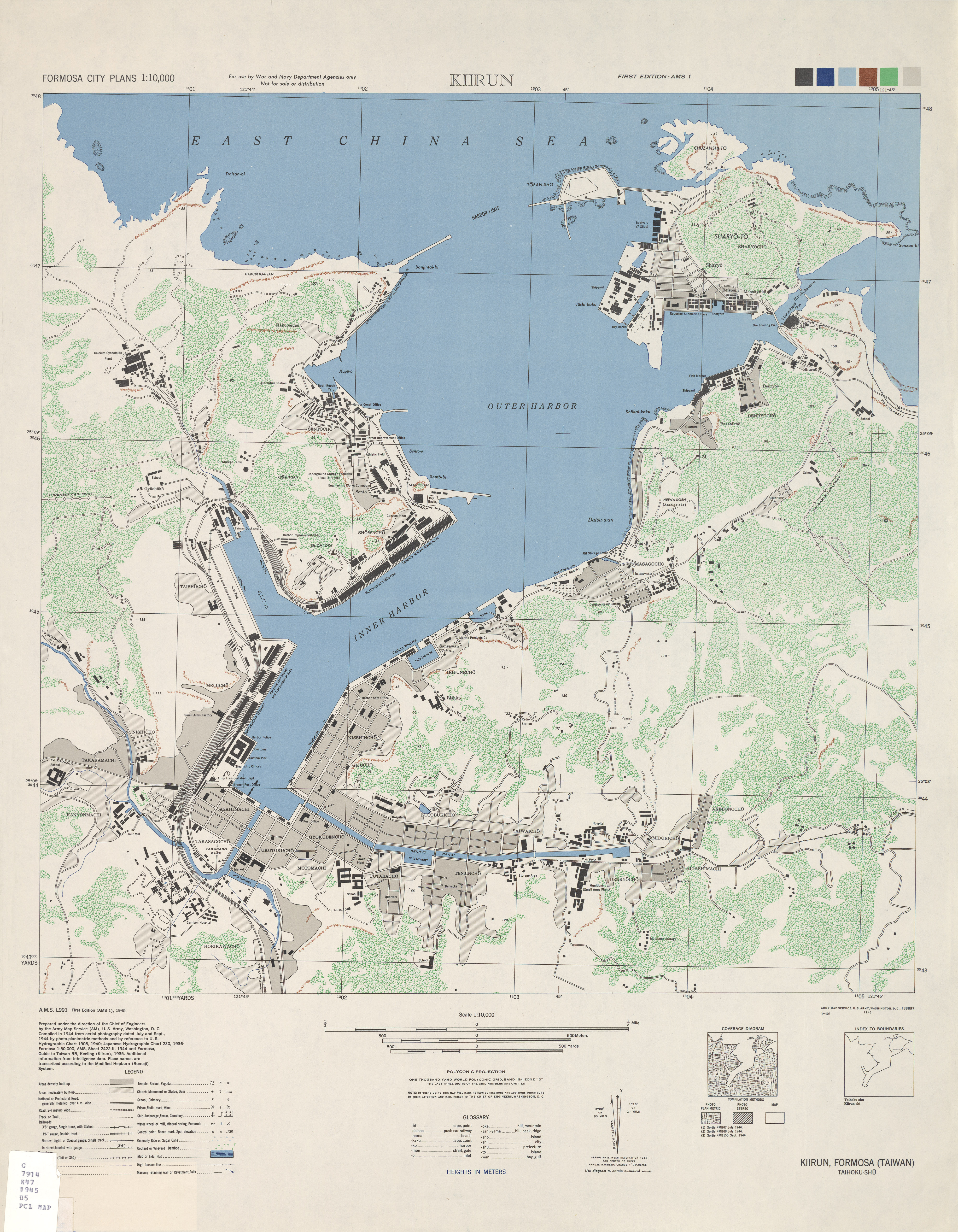
(click on map for much higher res image)


Getting Around

Car or Motorcycle: The route described in this section leaves National Highway 3 (H-3) at Mingjian Exit (236km marker), follows Provincial Route (PR)-16 [台16線] for about 28km through the towns of Jiji (集集鎮) and Shuili (水里鄉), and connects with PR-21 heading south (toward Sinyi [信義]). Road signs are well marked in both Chinese and English. The route continues on PR-21 [台21線] until it “becomes” PR-18 [台18線] at the PR-21 145km marker (near the Yushan National Park Visitors’ Center at Tatajia [塔塔加]). PR-18 can then be taken all the way down the mountain to the H-3 Jhongpu Exit (297km marker). The route may be traveled in reverse as well.

Train: Travelers focusing on the southern section of this itinerary (Yushan, Alishan and Fenqihu [奮起湖]) may consider taking the Alishan Forest Train (阿里山森林鐵路), which departs Jiayi Railway Station twice daily (once in the morning and afternoon). It is one of the world’s few high mountain railways still in operation and delivers (in fair weather) panoramic views largely missed from the roadway. (see this website for timetable, prices and online booking [sorry, Chinese only] or call (05) 225.1978). Travelers must reserve tickets in advance, which can booked up to 2 months ahead of time.

Bus: Buses, run by several different companies in different sections, make travel over this route possible, but inconvenient. Travel to Dongpu from the central West Coast is serviced by Yuanlin Motor Transport (tel: (04) 832.0101); a bus to Alishan from Jiayi City (and back) operated by Jiayi County (tel: (05) 278.8177) runs roughly every two hours until 3:10pm daily; also, Kuo-Kuang Motors (02.2311.9893) runs two round-trip buses between Taipei and Alishan every other day.

The Central Mountains offer regular reminders of nature’s ultimate dominion over us all. Snows occasionally close high passes during winter, and rockslides throughout the year mean that PR-21 is nearly always under repair. Driving across Yushan National Park after dark or during inclement weather should be avoided.


Applying for Hiking Permits: Hiking certain mountain trails requires prior registration with the local police precinct (警察局派出所). The procedure is simple and may be processed and approved immediately. Documents required include: 1) valid passport or ARC; 2) completed Application Form for Entering Restricted Mountain Areas (外國人入山申請書); and 3) processing fee (NT$10). The application form can be downloaded from here.

Accommodations: The area provides modest but comfortable accommodations in terms of both hotels and B&Bs. The following suggestions are provided for reference:

Dongpu Hot Spring Area
Sha Li Shian (沙里仙); 049.270.1289; website
Located 1km before the town of Dongpu; Spacious surroundings; Panoramic valley views.

Alishan/Yushan Area
Yushan Spring Coffee Inn: (玉山春天咖啡旅館); 05.267.9117; website
Located on PR-18 at the 83km marker between Tatajia and Alishan. Full view of Yushan and adjacent valley. Far from civilization, close to hiking and nature.

Fenqihu (Fenqihu)
Adagio (緩慢); 05.256.1314; website
Quiet location just before the old railway town of Fenqihu.


The Language Barrier: Major tourist destinations such as Alishan, Yushan and even Fenqihu (Fencihu) are relatively well covered in English. Other locations are less endowed. However, most sites introduced are near to the main route described and thus are relatively easy to reach. Taiwan’s mountains welcome visitors, so don’t hesitate to ask for direction assistance. Police stations, located in nearly every town along the way, are, I found, particularly willing and able to assist with inquiries.

-JM

2009-06-02

Keelung to Taipei in 01:03 (騎省道台五線輕鬆地打通基隆及台北的界線)


I’ve long taken to cycling around Keelung as a primary - rather than alternative - mode of transportation. With the exception of winters, which do get unpleasantly damp and dreary, the city and its immediate periphery are not just cyclable, but compact and ‘visually interesting’ - prompting feelings that many more people, with two good legs and an agenda not callling for heavy shopping, should leave their car or scooter in the garage and venture out on bicycles.

Apart from exercise and convenience, cycling allows ‘ponder time’ – time to think about this and that, including ways of making the immediate neighborhood, Taiwan and the world greener and more sustainable.

I’ve been cautioned by numerous friends and strangers of the dangers of Taiwan roadways - plagued as they are by fast drivers more concerned with getting to point B than with the occasional cyclist (or pedestrian) in the way. To this, I might add precariously double-parked vehicles, road debris, potholes, steep curbs and (particularly when caught at a stoplight behind a row of motorcycles) bad air. Most roads here simply are not ‘cyclable’ in the ideal sense of the word. Many a conversation has simply ended on that note. It would be wonderful if - by some adroit stroke of policy or, perhaps, by gasoline prices inching their way beyond the reach of casual motorists … or by more people simply electing to bike - more drivers began commuting hither and thither on bicycles.


As seen to some degree already in neighboring Taipei City, the simple act of installing recreational cycling trails around the urban periphery has spawned an entire new generation of cyclists happy to don quirky Styrofoam helmets and lug odd-looking 'collapsibles' onto the MRT. As more people propel themselves with pedal power, we naturally grow more aware of the potential and the need to make urban environments more ‘user friendly’. Pressures for real commuter bike trails, safer roads, better air quality, better regulations, better urban planning … all come gradually into play and help foster (hopefully) a better environment across the board. Keelung City, still visibly deficient in both imagination and self-confidence, remains, physically and spiritually, so far removed from any of this … but one must first dream.


Sign warns of malevolent local auto with some deep-seated issues about
motorcycles and those who ride them. Fortunately, it wasn't home when I passed by.

Xizhi - south of the river

I’ve circled the island by bike slightly more than twice now, and continue to enjoy distance cycling. One section I’d never previously biked, however, was that between Keelung and Taipei. Separated by just 25+ kilometers, getting between these two cities is pretty straightforward - simply requiring the braving of Provincial Route 5 (新台五路). However, I’d always pinned hopes on a gentler, nicer bicycle route opening along the Keelung River (基隆河), running, somehow, from around Nuan Nuan (暖暖) into downtown Taipei.


Now, with those river hugging trails still patchy, but at least three-quarters in place, I set out a couple of weeks ago to see how far I could get. I quickly found, however, that the river’s north-south sweeps add significant kilometers to little advantage. Turns out that the new and growing Keelung River Trail is much more suited to local recreators than to those looking to link to places further afield.

Once again, thoughts returned to Provincial Route 5. PR-5 follows roughly the route taken by the main roadway that connected Taipei to Keelung Port and northeastern Taiwan before completion of Taiwan’s first highway (中山高速公路) in 1978. Apart from a modest 1km incline to the road’s highest point in Xizhi (汐止市), PR-5 is a relatively smooth ride both to and from Taipei (this incline can be more or less avoided by following a detour which slices through the container yard district into Xizhi City - which will add an extra half km to your route).


For the serious ‘commuter’ biker, PR-5 is the only way to go, as it leads from downtown Keelung to downtown Taipei (at Zhongxiao and Nanjing East Roads) directly through the string of towns in between. What’s more, keeping a regular pace, it took me just 63 minutes to arrive at the center of Taipei (corner of Zhongxiao East & Dunhua North roads) from my Keelung apartment - just enough time to listen to REM’s In Time through to the beginning of 'Everybody Hurts' on the way there and Abba Gold through to the finish of ‘Does Your Mother Know’ on the way back. Driving into Taipei, if you include time spent hunting for parking, can sometimes add up to as much.

Over the past several weeks I’ve made three bicycle commutes into Taipei along PR-5 at different times of the day. Traffic is moderate and relatively non-threatening outside of rush hour, during which time the road gums up with motorcycles and cars wanting to avoid the NT$40 highway toll.


I’ve not seen other cycling ‘commuters’ taking this route, but hope there are at least a few regulars out there keeping this route warm. A properly demarcated bike lane along most of PR-5 would be an inexpensive and excellent first step forward toward encouraging commuters to cycle rather than drive between Keelung and Taipei and - perhaps more realistically to begin with - points in between.

- JM

2009-05-04

New NE Coast Walkway / Bike Path Opens (新開的外木山到翡翠灣的自行車步道)


After a sabbatical of nearly a year, I'm back with more articles and thoughts on life along Taiwan's Northeast Coast and travels around the beautiful island of Taiwan.


I took the afternoon this past Sunday to collect thoughts; ponder the meaning of life, the universe and Everything and get some exercise during a spell of balmy spring weather. I frequently cycle the Keelung (基隆市) to Feicui (Jade or Green) Bay [翡翠灣] route, and my mettle has been oft tested ... and cycling direction occasionally diverted ... by cognizance of the challenges presented by the formidable hills straddling the Keelung City / Taipei County border - just ahead of the fishing town of Wanli (萬里鎮).


This time, cycling through Dawulun (大武崙) and then huffing up Provincial Route 2, which follows a coastal ridge overlooking Dawulun Fishing Port (大武崙漁港) & Waimushan Beach (外木山海水浴場), I was pleasantly surprised to find myself paralleling a new wood planked walkway installed to connect Dawulun Fishing Port (the walkway actually starts from the nearby pink [and now defunct] outdoor swimming complex-cum-seafood restaurant) to Wanli's fishing harbor, next to the wide sand beach along Feicui Bay. The walkway skirts the coast, avoiding hills and attendant steep grades. Very pleasant - with panoramic views of the rocky shoreline and Keelung Islet in the distance.


While this new walkway and bike path extends just 2.5km, when packaged together with the readily biked coastal roadways further westward and the 2-year old bike path that connects Waimushan Beach almost into Keelung City's busy downtown, cyclers can now navigate relatively easily a pleasantly undulating coastal route from downtown Keelung out as far as Yeliu (野柳), Jinshan (金山) and beyond.


This section of the coast is simply gorgeous, passing several sand beaches and majestic sandstone formations (including the 'Frozen Beach' outcropping just before Yeliu), as well as several 'human interest' points including pre-fab 'UFO' vacation bungalows (great pics here) just east of the Howard Plaza Green Bay Resort; northern Taiwan's main jump-point for hang gliding; trails leading up to the Japanese-era Dawulun Fort (大武崙砲臺) and several shallow, easy-to-access snorkeling / diving areas.

Departing from Keelung City, a cycling trip to Jinshan can be done in under 1.5 hours (one-way) taking advantage of the new coastal walkway. Plan on much more time, however, to enjoy all the out-of-the-way attractions this 25km stretch of coastline has to offer. If planning to walk, I recommend driving Route 2 to Waimushan Beach (map location here), where there is usually adequate parking space, and exploring the area from there.

Just a note ... To check out the deteriorating (albeit quite photogenically) Reagan-era fiberglass-reinforced 'UFO' vacation bungalows without paying for Howard Plaza Resort admission - cycle or walk through the narrow alley immediately to the left of the 7-11 on Route 2. The alley takes a few short jogs before opening onto the bungalow district and adjacent sand beach.


A Google Map rough-and-dirty guide to the approximate route from Keelung City out to Jinshan can be viewed by opening the link here.

- JM