The "importance" of Keelung, as with Taiwan itself, is much more accident of history than expression of intrinsic character. Nevertheless, the human drama that has played out here over the past few centuries give it a charm, which, after scratching the surface, has held my interest and piqued my curiosity to learn more.

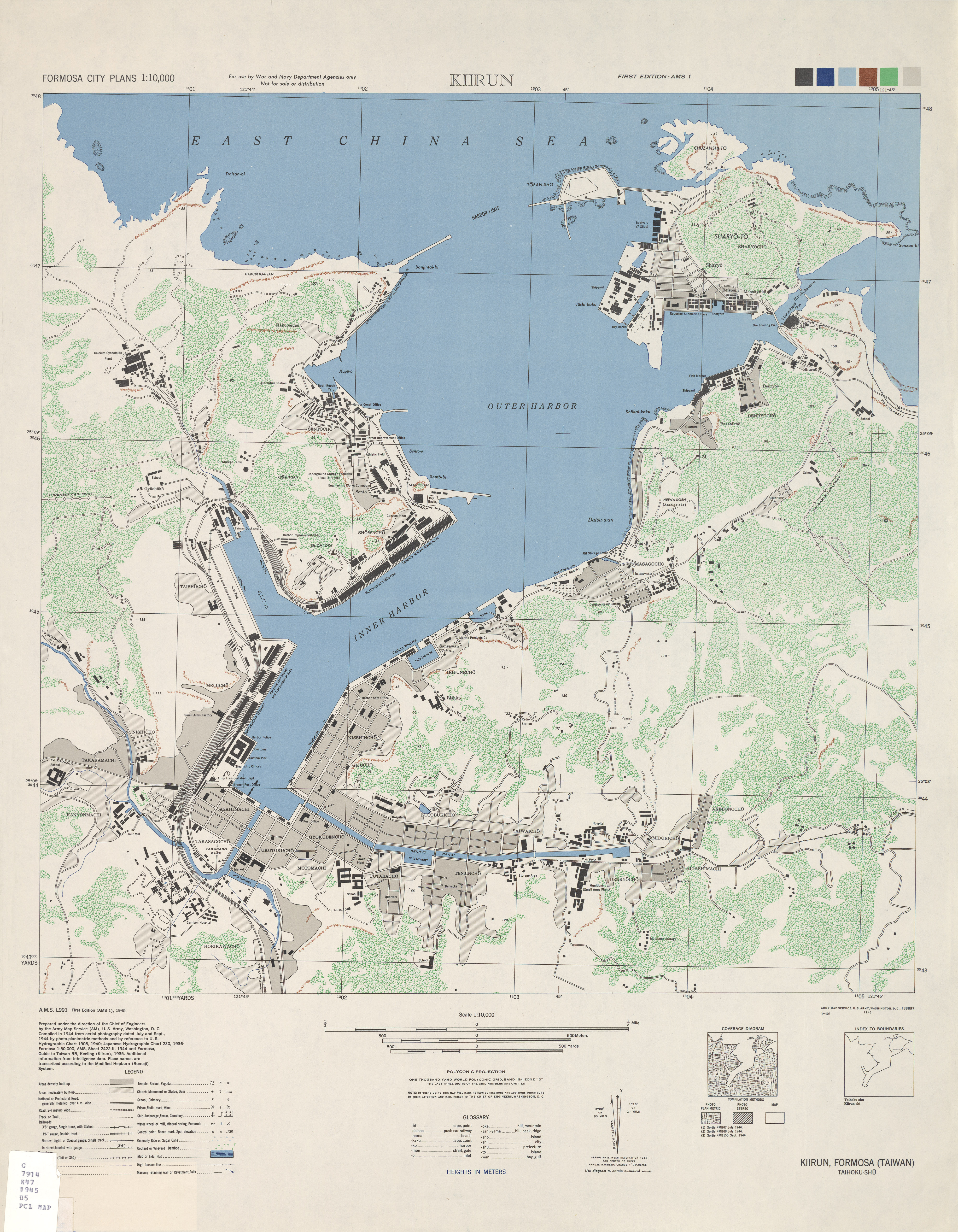
Downtown Keelung occupies an incredibly small patch of level real estate, centerpieced by a large commercial harbor. Over the past half century, the city has grown up ... and out ..., leaving the cramped downtown districts stuck with sad-looking multi-story buildings fronting mostly two-lane streets that, while likely suiting the town 50 years ago, now only add to reasons to visit the city only on weekdays, when things are relatively calm and most people are elsewhere.
From the harbor, moving a kilometer or so in most any direction takes you out of the city and into green hills. The whole Northeast Coast, with Keelung somewhere in the middle, rides atop the eastern edge of the Eurasian Plate. Unlike further south, where the entire plate has been pushed skyward (along Qingshui / Cingshuei Cliff [清水斷崖]), Eurasia seems to have ... well ... crumbled in northern Taiwan along numerous faults, which have since gone their own way to fashion today's complex topography of mild slopes and precipitous dropoffs. Some of these mini-faults drew magma to the surface, which further complicated the terrain with volcanic protrusions like the Yangming Mountains, Keelung & Turtle Islets (基隆嶼 / 龜山島), and the mineral-rich hills around Jinguashih (金瓜石).
For me, this is what makes Keelung - beyond city center - a cool place to hike, explore and enjoy.

I wrote the following some time ago to tie together for myself some of the important historical threads woven into this corner of Taiwan.
Reluctant Crossroads
Keelung's Incommodious Introduction to Modernity
當中西相遇 - 基隆簡史
Keelung (基隆市) is Taiwan's second largest port and fifth largest city, with narrow, congested streets, busy seafood restaurants, and a night market (Miaokou, 廟口) that draws uncomfortably large numbers of visitors on weekends. International trade drives this bustling town of 375 thousand and commerce pumps briskly through its veins.

This was not always the case. When imperial Chinese officials, at the head of a sprawling and largely self-sufficient continental empire, were forced to open Keelung to foreign trade in 1860 (under the Treaty of Tientsin [天津條約], which ended the Second Opium War), they would have been hard pressed to describe the town beyond its position on a map.
In 1860, Keelung comprised settlements on and around Keelung Bay, with a combined population of probably no more than five thousand. Fishermen here sold their catch to traders, who would haul goods by foot and sampan to markets on the agricultural plain some 30km inland. Residents grew rice, vegetables, and tea in the valleys and on the alluvial plain. Coal deposits, found throughout the Keelung area and of great interest to foreign powers, were widely speculated about, but, as of yet, worked only on a small scale.

Indeed, until 1891, when the opening of China's first commercial railway provided a more or less stable link between the port and the flourishing inland outpost of Banka (Manka / Taipei), Keelung residents lived largely isolated from the rest of Taiwan behind a curtain of abrupt hills and narrow river valleys. Even at the dawn of the 20th century, footpaths through these hills were still the chief means of getting to and from the town. They made an overland commute to anywhere else a serious undertaking.
Keelung has always looked to the sea for its livelihood and for greater purpose. Japanese and Chinese adventurers and pirates, perhaps some of the island's first residents from the Asian mainland, established long-term encampments along the Keelung narrows (on and around Peace Island [和平島]) as early as the 15th century. The Spanish, then Dutch, built permanent fortifications here during the 17th century as way stations for lucrative trade with Japan and China, and (for the Spanish) for the galleon trade between Asia and the Americas.
Formal Chinese rule in Taiwan first came in 1661 when General Koxinga (a.k.a. Zheng Chenggong, 鄭成功), champion of the vanquished Ming dynasty (1368-1644), regrouped his forces on the island following successive defeats in China against the empire's new Manchu (Qing) rulers. Koxinga besieged the ill-prepared forces of the Dutch East India Company on Taiwan and accepted the surrender of all Dutch outposts on the island the following year. From Keelung and other Taiwan harbors, Koxinga and his successors harassed shipping up and down the China coast until 1683 when, weakened by internal squabbles and the resolve of its adversary, Koxinga's Taiwan was absorbed into the ascendant Qing dynasty. Used to the Manchurian plains and highly suspicious of the open sea, the Qing largely ignored China's water links with the outside and limited coastal trade. Keelung faded into obscurity for nearly two centuries.

The 1860 Treaty of Tientsin ignited a commercial revival in Keelung that hummed along for two decades. Trans-Pacific steamers hauling cargo from China to the Americas called regularly at the port to take on fuel; coal mining grew into a major industry (In 1881, Keelung produced about 60,000 tons of mostly bituminous coal); and the town became a hub for a flourishing Chinese domestic trade across the Straits.
Occupation by France during the Sino-French War (1883-1885) destroyed most of Keelung and warned Qing officials that success as a steamship depot had made the town an all too tempting target for acquisitive colonial powers. Their fears were not unfounded. China's loss of Hong Kong Island to Britain in 1842 was followed in succession by the loss of other strategic ports including Shanghai (上海), Weihai (威海, Weihaiwei - to Britain), Qingdao (青島, Kiautschou - to Germany), Zhanjiang (湛江, Kouang-Tchéou-Wan - to France), and Lushun (旅順, Port Arthur - to Russia ... and then Japan). Further improvements to the harbor were suspended and the town went to seed. Even the landmark 1891 rail link to Taipei was described as rickety and unreliable only four years after its completion. Western steamships no longer called and the last of Keelung's foreign merchants left to pursue more profitable investments.
Keelung's fate took a final, abrupt turn when Japan took control in 1895. The Japanese, recent converts to imperialism who lacked the natural resources of other Great Powers, were eager to exploit Taiwan's agricultural and mineral wealth. Officials gave top priority to constructing modern commercial and transportation infrastructures geared to channel goods to and from Japan. The harbor was dredged and expanded, new docks were built, and Keelung was turned into a modern colonial city - soon overtaking Tamsui as Taiwan's busiest port. Trade leapt by a factor of thirty in 5 years - from $225 thousand in 1896 to nearly $7 million in 1901. Trade through Keelung included large volumes of tea, camphor, China grass (for straw hats and rope), Japanese manufactured goods, and opium.

Decimated by US bombers during the Second World War, harbor facilities were gradually rebuilt and enlarged after Taiwan was handed over to Nationalist Chinese control in 1945. While Kaohsiung has since eclipsed the city as Taiwan's most important commercial port, Keelung remains today a critical portal for the island's export-driven economy. Beyond Keelung's hopelessly congested city center, quiet alleys and fern shaded hills stand silent guard over important reminders, in numerous fortifications and historic trails, of the city's interesting and often turbulent past.
- JM


